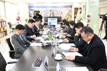
이날 간담회는 홍수대응을 위한 취약지구 조사결과를 해당지역 지자체 및 주민과 공유하여 홍수발생 시 신속하고 효율적인 대응을 위한 유기적인 협력체계를 구축하는데 목적이 있다고 했다.
원주지방환경청은 관내 9개 국가하천에 대해 2월 16일부터 3월 18일까지 수자원공사, 지자체 등과 홍수취약지구 지정·관리를 위한 관계기관 합동조사를 실시하여, 홍수취약요소를 가진 66곳을 선정했다고 전했다.
조사 결과, 계획홍수위보다 제방이 낮은 월류위험 구간이 55곳, 횡단교량으로 인한 구조적 취약구간이 5곳, 홍수관리구역이 3곳, 배수위 영향구간 중 국가하천 제방보다 낮은 구간이 2곳 순으로 원주지방환경청 관내 총 66곳이 홍수취약지구로 관리중에 있다고 했다.
홍수취약지구로 선정된 지역은 홍수통제소와 협의를 거쳐 홍수정보 제공지점으로 등록·관리하고 하천수위 변동 및 댐방류 정보 등을 하천관리청, 지역주민 등 관계기관 간 실시간으로 공유할 예정이라고 했다.
또한, 홍수취약요소에 대하여는 하천기본계획 수립 등에서 제방 보축 등을 검토, 개선안을 마련하고 하천정비사업에 포함하여 적극적이고 지속적인 관리와 개선을 추진할 계획이라고 했다.
이창흠 청장은 “이번 홍수취약지구 조사결과를 지역협의체 간담회를 통해 해당지역 주민과 공유하였으며, 지자체 및 관계기관과 긴밀한 협조체계를 구축해 올해 홍수기 대비에 최선을 다하겠다”고 밝혔다.
*아래는 위 기사를 '구글 번역'으로 번역한 영문 기사의 [전문]입니다. '구글번역'은 이해도 높이기를 위해 노력하고 있습니다. 영문 번역에 오류가 있을 수 있음을 전제로 합니다. *The following is [the full text] of the English article translated by 'Google Translate'. 'Google Translate' is working hard to improve understanding. It is assumed that there may be errors in the English translation.
Wonju Regional Environment Agency formed a regional consultative body to strengthen flood response capabilities
Establishment of a cooperative system to share flood information with local residents
[Reporter Il-woong Kim = Northern Gyeonggi/Gangwon] The Wonju Regional Environment Agency of the Ministry of Environment announced on the 15th that in order to respond quickly and efficiently in the event of a flood, a local council was formed and held a meeting with related organizations and local residents.
The purpose of the meeting was to establish an organic cooperative system for prompt and efficient response in the event of a flood by sharing the results of the investigation of vulnerable districts for flood response with local governments and residents.
The Wonju Regional Environment Agency conducted a joint investigation with the Water Resources Corporation, local governments, and related agencies for designation and management of flood-vulnerable areas from February 16 to March 18 on 9 national rivers, and identified 66 areas with flood-vulnerable factors. said to have been selected.
As a result of the survey, there were 55 overflow risk sections with embankments lower than the planned flood level, 5 structurally vulnerable sections due to cross-bridges, 3 flood management areas, and 2 sections lower than the national river embankment among the drainage level affected sections. A total of 66 areas within the Wonju Regional Environment Agency are under management as flood-vulnerable areas.
Areas selected as flood-vulnerable areas will be registered and managed as flood information provision points after consultation with the flood control center, and river water level changes and dam discharge information will be shared between relevant organizations such as the river management office and local residents in real time.
In addition, he said that for flood-vulnerable factors, he plans to review embankment extensions, etc. in the establishment of a river master plan, prepare an improvement plan, and include it in the river maintenance project for active and continuous management and improvement.
Commissioner Chang-heum Lee said, "We shared the results of this flood-vulnerable district survey with local residents through a meeting with local councils, and we will do our best to prepare for this year's flood season by establishing a close cooperation system with local governments and related organizations."
이 기사 좋아요
<저작권자 ⓒ 브레이크뉴스 경기북부 무단전재 및 재배포 금지>

댓글
김일웅 기자, 원주지방환경청, 지역협의체, 홍수, 효율적인 대응 관련기사목록
|
많이 본 기사
환경 많이 본 기사
|


